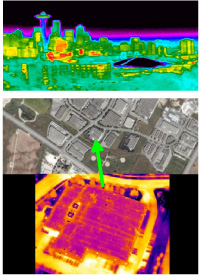
Nasa is planning an ambitious program to map the thermal heat signature of the entire US, building by building. The project was created to study the effect building heat loss has on global temperature variation and will require hundreds of Micro blimps to accomplish.The study could take up to 3 years to complete and the goal is to make a heat signature map of at least 1 million industrial and residential structures.
Scientists have been studying the climate models for years and their methods have become more accurate at measuring temperature on a regional basis but this study will give Nasa detailed infrared information for a massive data base of man made structures and will enable them to pinpoint areas and give them a new level of information and a better idea of how building heat loss effects Climate Change.
The helium filled Micro UAV’s are about 6 feet long and may or may not be visible from the ground depending on their altitude, which is expected to be about 2000 feet. They will be deployed in all 50 states and the blimps will fly at night and in daylight for up to 6 hours at a time at speeds averaging 15 miles per hour. The Micro UAV’s will communicate wireless and will follow a preprogrammed GPS guided route through there designated course.
Once all the information is gathered and analyzed it will not only give scientists a better understanding of global temperature change but it is hoped that in the near future heat signatures could be provided for all structures giving city and state governments information on how to improve building codes. Property owners could be given a free heat signature profile so they could compare their score with neighbors and people would have a better idea on how to improve their score which could lead to huge energy and cost savings for home owners.


